Nestled in the rolling grasslands of southern Arizona, Sonoita Creek State Natural Area represents one of the state’s most pristine riparian ecosystems. Established in 1995 as Arizona’s first state natural area, this 9,159-acre conservation space protects the perennial Sonoita Creek, one of the few year-round flowing streams in this arid region. Located near the town of Patagonia in Santa Cruz County (31.5056° N, 110.7640° W), the natural area sits approximately 60 miles southeast of Tucson and 18 miles northeast of Nogales.
Unlike typical state parks designed primarily for recreation, Sonoita Creek State Natural Area was created with conservation as its primary mission. The area safeguards the important watershed between Patagonia Lake and the town of Patagonia, preserving critical habitat for hundreds of bird species and diverse wildlife. The natural area is administratively connected to Patagonia Lake State Park but offers a distinctly different experience focused on minimal development and natural resource protection.
What makes this natural area truly special is its biodiversity. The riparian corridor along Sonoita Creek represents less than 1% of Arizona’s landmass but supports over 80% of its wildlife diversity. Visitors will discover a remarkable transition zone where the Sonoran and Chihuahuan Deserts meet, creating a biological crossroads where species from both ecosystems thrive alongside unique riparian inhabitants.
Key highlights include some of the oldest and largest Fremont cottonwood trees in the United States, exceptional bird watching opportunities with over 300 documented species, and pristine hiking trails that showcase undisturbed desert and riparian landscapes. The area’s conservation status ensures that visitors experience a slice of Arizona as it existed centuries ago, before extensive development altered much of the state’s natural waterways.
| Detail | Information |
|---|---|
| Location | Adjacent to Patagonia Lake State Park, southern Arizona |
| Established | 1994 |
| Size | Approximately 5,000 acres |
| Water Features | Sonoita Creek, one of southern Arizona’s few permanent streams |
| Ecological Significance | Rare riparian habitat, protected conservation area |
| Elevation | 3,750-4,800 feet |
| Biodiversity | Supporting over 100 species of native trees, plants, and grasses |
| Bird Species | More than 300 species recorded, important migratory corridor |
| Notable Birds | Gray hawks, vermilion flycatchers, elegant trogons, varied hummingbirds |
| Wildlife | Coatimundi, white-tailed deer, javelina, bobcats, mountain lions |
| Vegetation | Cottonwood-willow riparian forest, mesquite bosque, desert grassland |
| Trails | Several miles of hiking trails with varying difficulty |
| Notable Trail | Coal Mine Spring Trail, Creek Trail |
| Activities | Hiking, bird watching, wildlife viewing, photography, research |
| Access | Limited access, permits may be required for certain areas |
| Conservation Focus | Protection of riparian habitat and endangered species |
| Guided Tours | Available from Patagonia Lake State Park (seasonal) |
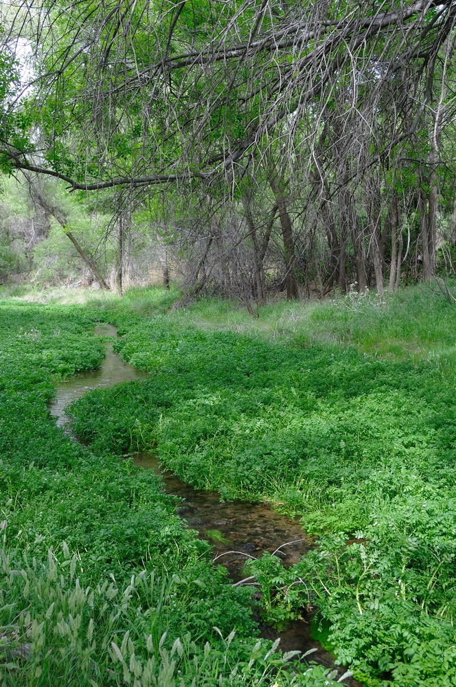
Sonoita Creek forms the lifeblood of this natural area, flowing approximately 7.5 miles from the town of Patagonia to Patagonia Lake. This perennial stream maintains year-round water flow, a rarity in the arid Southwest, though flow volumes fluctuate seasonally. During monsoon season (July through September), the creek can transform from a gentle stream to a substantial waterway after heavy rainfall.
The watershed encompasses approximately 209 square miles, collecting water from the surrounding Patagonia Mountains to the south and the Santa Rita Mountains to the north. This crucial water source not only sustains the natural area but eventually feeds into the Santa Cruz River, a major watershed for southern Arizona.
The landscape surrounding Sonoita Creek features dramatic topographical diversity. Elevations range from approximately 3,500 feet at Patagonia Lake to 4,800 feet in the northern reaches of the natural area. This elevation variation creates distinct ecological zones as visitors move from the creek’s riparian corridor to the mesquite-studded grasslands and oak woodlands at higher elevations.
Geologically, the area showcases the complex history of southern Arizona. The underlying bedrock includes volcanic formations dating back to the Tertiary period (approximately 66 million to 2.6 million years ago), as well as more recent alluvial deposits along the creek bed. These geological foundations support diverse soil types, from sandy creek bottoms to rocky upland terrain, enabling the area’s remarkable plant diversity.
A noteworthy geological feature is Coal Mine Spring, where historical prospecting for coal occurred in the early 1900s. While the mining ventures proved unsuccessful, the spring continues to provide a critical year-round water source for wildlife, particularly during drought periods when sections of Sonoita Creek may run dry.
The riparian corridor itself varies in width from approximately 200 feet to nearly half a mile in some sections, creating a green ribbon of life through the otherwise arid landscape. This corridor not only provides crucial habitat but also serves as an essential migration route for birds and other wildlife moving between Mexico and the United States, highlighting the international conservation significance of this relatively small natural area.
INSIDER TIP: Visit Coal Mine Spring during early morning hours for the best wildlife viewing opportunities. Many species come to drink at this reliable water source, especially during the dry months of April through June.
The botanical diversity of Sonoita Creek State Natural Area is exceptional, reflecting its position at the convergence of several ecological zones. The riparian corridor showcases massive Fremont cottonwood trees (Populus fremontii), some estimated to be over 130 years old with trunk diameters exceeding 6 feet. These ancient giants create a cathedral-like canopy along the creek, sheltering a rich understory of Goodding’s willow (Salix gooddingii), seep willow (Baccharis salicifolia), and Arizona walnut (Juglans major).
Moving away from the creek, visitors encounter mesquite bosques dominated by velvet mesquite (Prosopis velutina), with an understory of native grasses including blue grama (Bouteloua gracilis) and various muhly species (Muhlenbergia spp.). At higher elevations, the natural area transitions to oak woodlands featuring Emory oak (Quercus emoryi) and Mexican blue oak (Quercus oblongifolia), interspersed with juniper and occasional Arizona sycamore (Platanus wrightii).
The natural area serves as a refuge for several rare plant species, including the Huachuca water umbel (Lilaeopsis schaffneriana var. recurva), federally listed as endangered. Conservation efforts focus on protecting and expanding populations of this aquatic plant that requires stable, perennial water sources.
Wildlife diversity is equally impressive, with the area serving as habitat for over 300 bird species. Notable avian residents and migrants include the vermilion flycatcher, elegant trogon, varied bunting, and over 20 species of hummingbirds. The creek corridor provides essential habitat for the federally endangered Southwestern willow flycatcher (Empidonax traillii extimus) and the threatened Western yellow-billed cuckoo (Coccyzus americanus occidentalis).
Mammals found within the natural area include white-tailed deer, javelina, coatimundi, bobcat, and the occasional mountain lion. The riparian zone provides prime habitat for several bat species, including the endangered lesser long-nosed bat (Leptonycteris curasoae yerbabuenae) that feeds on the nectar of agave and saguaro cactus blooms.
The creek itself supports populations of native fish, including the Gila topminnow (Poeciliopsis occidentalis occidentalis) and longfin dace (Agosia chrysogaster). Conservation programs actively work to remove non-native fish species that threaten these indigenous populations.
Seasonal changes dramatically transform the natural area. Spring (March-May) brings wildflower blooms and the arrival of migratory birds. Summer (June-September) sees the emergence of reptiles and monsoon-triggered plant growth. Fall (October-November) showcases cottonwood foliage in brilliant yellow, while winter (December-February) offers opportunities to observe raptors and year-round resident species.
Sonoita Creek State Natural Area offers a more contemplative recreational experience than many other state parks, focusing on low-impact activities that align with its conservation mission.
The natural area features approximately 20 miles of trails ranging from easy creek-side paths to challenging upland routes. All trails are for hiking only; no mountain biking or equestrian use is permitted to minimize environmental impact.
Notable trails include:
Creek Trail (2.5 miles, easy): This accessible trail follows Sonoita Creek, offering spectacular views of the riparian habitat and opportunities to see water birds. The trail features minimal elevation change and several interpretive signs explaining the ecosystem.
Overlook Trail (3.2 miles, moderate): Climbing approximately 500 feet in elevation, this trail provides panoramic views of the entire watershed, Patagonia Lake, and surrounding mountains. The trail traverses grassland and oak woodland habitats.
Coal Mine Spring Trail (4.1 miles, moderate): Leading to the historical Coal Mine Spring, this trail showcases the transition from riparian to upland habitats and offers excellent wildlife viewing opportunities.
New Mexico Connection Trail (6.8 miles, difficult): The most challenging trail in the natural area, this route explores the northeastern section with significant elevation changes and minimal shade. Recommended for experienced hikers only, especially during summer months.
IMPORTANT ALERT: Most trails have minimal or no shade. Hikers should carry at least one gallon of water per person during summer months, wear sun protection, and avoid midday hiking from May through September.
The natural area is internationally renowned for bird watching, with serious enthusiasts traveling from around the world to add rare species to their life lists. The creek corridor is designated as an Important Bird Area by the National Audubon Society.
Prime bird watching locations include:
The natural area maintains several wildlife viewing blinds strategically placed near water sources. Early morning (6-9 AM) and late afternoon (4-7 PM) provide the best wildlife viewing opportunities.
The diverse landscapes, from towering cottonwoods to expansive grasslands, offer exceptional photography opportunities. The natural area is particularly known for:
While Patagonia Lake (adjacent to the natural area) offers extensive fishing opportunities, fishing within Sonoita Creek State Natural Area is limited to catch-and-release only and restricted to designated areas to protect sensitive native fish populations. Anglers must obtain both an Arizona fishing license and a special permit from the visitor center before fishing in the natural area.
With minimal light pollution, the natural area provides excellent stargazing opportunities. Though the area closes at sunset for day use visitors, overnight educational programs occasionally offer guided astronomy activities during special events.
Sonoita Creek State Natural Area itself does not offer developed camping facilities, emphasizing its primary mission of conservation over recreation. However, several camping and accommodation options exist in the immediate vicinity.
Located adjacent to the natural area, Patagonia Lake State Park offers 105 developed campsites suitable for tents and RVs. These sites include:
Campsite amenities include:
Reservations are strongly recommended, particularly during peak season (October-April) and can be made up to 12 months in advance through the Arizona State Parks reservation system online or by calling 1-877-MY-PARKS. Rates range from $20-35 per night for standard sites and $89-119 for cabins, depending on season and amenities.
For those seeking a more rustic experience, the Coronado National Forest (surrounding much of the natural area) permits dispersed camping with appropriate permits. These primitive sites have no amenities but offer solitude and direct access to forest trails that connect to the natural area. Contact the Coronado National Forest Sierra Vista Ranger District at (520) 378-0311 for current regulations and permits.
The nearby town of Patagonia (4 miles north) offers several lodging options:
The community of Sonoita (15 miles northeast) provides additional accommodations:
While camping is not permitted within the natural area boundaries, visitors planning to explore from nearby accommodations should note:
INSIDER TIP: The Patagonia Lake boat-in campsites offer the most direct early morning access to the natural area’s eastern trails. These sites fill quickly during peak bird migration seasons (April-May and August-September).
Sonoita Creek State Natural Area is open for day use only, from sunrise to sunset year-round. The visitor center operates from 8:00 AM to 5:00 PM daily from October through April, with reduced hours (8:00 AM to 4:00 PM, Thursday through Monday) from May through September.
The natural area experiences distinct seasons, each offering unique visitor experiences:
Fall (October-November): Perhaps the most pleasant time to visit, with moderate temperatures (60-80°F daytime), fall colors in the riparian areas, and good wildlife activity. Bird migration is significant, particularly in late September through October.
Winter (December-February): Mild daytime temperatures (50-65°F) with cold nights (occasionally below freezing). Winter brings numerous raptors to the area and excellent visibility across the landscape. Occasional snow is possible but rarely lasts more than a day.
Spring (March-May): A popular season for wildflowers and peak bird migration. Temperatures are moderate (65-85°F) with occasional strong winds, particularly in April. Water flow in Sonoita Creek is typically strong following winter precipitation.
Summer (June-September): The challenging season, with daytime temperatures regularly exceeding 95°F, though the higher elevation (compared to Tucson) moderates extremes somewhat. Monsoon storms (typically July-September) bring spectacular cloud formations, potential flash flooding, and renewed plant growth. Morning visits are strongly recommended during summer.
Access to Sonoita Creek State Natural Area requires payment of a fee, which supports conservation efforts:
These fees can be paid at either the Patagonia Lake State Park entrance station or at the Sonoita Creek Visitor Center. Visitors should keep their receipt visible in their vehicle when parked at trailheads.
Annual passes that provide access include:
The natural area’s weather can change rapidly, particularly during monsoon season. Visitors should check forecasts before arrival and be aware of:
Average temperatures by season:
Annual precipitation averages 18 inches, with approximately half occurring during the monsoon season.
Sonoita Creek State Natural Area offers limited accessibility for visitors with mobility challenges due to its undeveloped nature. However, efforts have been made to provide some accessible features:
Visitors with mobility or other accessibility needs should contact the visitor center in advance at (520) 287-2791 to discuss specific accommodations and current trail conditions.
To protect sensitive wildlife, pets are permitted only in designated areas of the natural area:
Cell phone coverage within the natural area is spotty at best. Visitors should expect:
Visitors should download maps and information before arrival and inform others of their hiking plans when exploring remote sections of the natural area.
The facilities at Sonoita Creek State Natural Area are intentionally minimal to preserve the natural environment, but several amenities are available to enhance visitor experiences.
The Sonoita Creek Visitor Center, located near the northeastern entrance, serves as the primary information hub for the natural area. Facilities include:
The visitor center offers scheduled nature talks and guided walks (October-April), focusing on topics such as bird identification, native plants, and regional geology. These programs are typically offered Friday through Sunday and can be booked at the center or by calling (520) 287-2791.
Restroom facilities within the natural area are limited:
For full facilities with running water and flush toilets, visitors can use the restrooms at adjacent Patagonia Lake State Park.
Several designated picnic areas are located within the natural area:
All picnic areas operate on a first-come, first-served basis and include trash receptacles. No cooking or fires are permitted; only cold food preparation is allowed.
The natural area maintains several specialized wildlife viewing facilities:
These facilities include interpretive signage identifying common species and optimal viewing times.
The Sonoita Creek Field Station, while primarily used for research and not generally open to the public, occasionally hosts educational programs and citizen science opportunities. Special events at the field station are announced on the Arizona State Parks website and at the visitor center.
The visitor center offers a limited equipment loan program (valid ID required):
These items are available on a first-come, first-served basis for day use only.
IMPORTANT ALERT: There are no food concessions, stores, or vending machines within the natural area. Visitors should bring all necessary food and water. The nearest supplies are available in Patagonia (4 miles) or at Patagonia Lake State Park marina (1 mile).
Sonoita Creek State Natural Area serves as an excellent base for exploring southern Arizona’s natural and cultural destinations.
Immediately adjacent to the natural area, this popular park offers:
Managed by The Nature Conservancy, this 873-acre preserve protects the upper reaches of Sonoita Creek:
This 45,000-acre grassland preserve is located 20 miles northeast:
This eclectic community of approximately 900 residents offers:
Located at the junction of Highways 82 and 83, this small community serves as the hub of Arizona’s wine country:
Located 30 miles west, this historic park preserves the site of the first European settlement in Arizona:
Just 25 miles southwest, this national park preserves an 18th-century Spanish mission:
Located in Nogales (18 miles south), this museum chronicles the region’s multicultural heritage:
Sonoita Creek State Natural Area represents one of Arizona’s most important conservation success stories, preserving critical riparian habitat in an ecosystem where over 90% of such environments have been lost to development or water diversion.
The natural area actively manages several conservation initiatives:
Working in partnership with Arizona Game and Fish Department, the natural area maintains sections of Sonoita Creek as refuges for endangered native fish species:
These efforts include removal of non-native species, habitat enhancement, and regular population monitoring.
A continuous effort to control non-native plant species focuses primarily on:
Management techniques include targeted removal, native species restoration, and seasonal prescribed burns in specific upland areas.
Collaborative efforts with upstream landowners and the town of Patagonia work to ensure water quality and quantity sufficient to maintain the perennial flow of Sonoita Creek. These programs include:
Visitors play a crucial role in conservation through responsible recreation:
The natural area offers several volunteer programs for visitors interested in deeper involvement:
Interested volunteers should contact the volunteer coordinator at (520) 287-2791 or visit the Arizona State Parks volunteer portal online.
Education forms a cornerstone of the natural area’s mission:
The natural area promotes Leave No Trace principles through all visitor interactions:
Sonoita Creek and its surrounding lands hold deep cultural significance spanning thousands of years of human history.
The watershed falls within the traditional territories of the Tohono O’odham and Apache peoples, who utilized the perennial waters and abundant wildlife. Archaeological evidence indicates human presence dating back approximately 2,000 years, with seasonal encampments focused on harvesting mesquite beans, hunting, and gathering riparian plants for medicinal and ceremonial purposes.
Spanish exploration entered the region in the 1690s with Father Eusebio Kino’s missionary expeditions. The Sonoita Creek watershed was documented in early Spanish maps as “Zonita,” likely a Spanish approximation of an O’odham place name referring to the foggy conditions often found in the creek valley during winter mornings.
By the 1850s, European-American settlement began in earnest following the Gadsden Purchase. The creek corridor supported small-scale agriculture, while the surrounding uplands were utilized for cattle ranching. The town of Patagonia developed as a mining community, with several small mines operating in the hills surrounding Sonoita Creek.
Water rights conflicts emerged by the early 1900s as increasing demands strained the creek’s flow. Historical documents indicate that sections of Sonoita Creek that now flow year-round were regularly dry during summer months in the early 20th century due to agricultural diversions.
Conservation efforts began in the 1960s when The Nature Conservancy established the Patagonia-Sonoita Creek Preserve to protect the upper sections of the creek. The creation of Patagonia Lake in 1968 dramatically altered the lower watershed, transforming a section of free-flowing creek into a reservoir primarily for recreation and flood control.
The establishment of Sonoita Creek State Natural Area in 1995 represented a significant shift toward ecosystem-based management for the middle section of the creek. The natural area now serves as a vital ecological link between the Nature Conservancy preserve upstream and Patagonia Lake downstream, creating a conservation corridor that preserves much of the creek’s natural function.
Today, the natural area continues to balance its conservation mission with providing opportunities for visitors to experience one of southern Arizona’s most important riparian ecosystems—a living link to the region’s ecological and cultural heritage.
Q: How is Sonoita Creek State Natural Area different from other Arizona State Parks?
A: Unlike traditional state parks focused primarily on recreation, Sonoita Creek State Natural Area was established specifically for conservation, with recreation as a secondary purpose. This means facilities are minimal, and management decisions prioritize ecological health over visitor conveniences.
Q: When is the best time for bird watching in the natural area?
A: While bird watching is rewarding year-round, peak migration periods in April-May and August-September offer the greatest diversity. Winter (December-February) is excellent for raptors and waterfowl, while summer brings unique species like the elegant trogon and varied bunting.
Q: Can I bring my dog on the trails?
A: Dogs are permitted only on the Creek Trail and must be leashed at all times. They are not allowed on other trails to minimize disturbance to wildlife.
Q: Is camping available within the natural area?
A: No camping is permitted within Sonoita Creek State Natural Area. However, adjacent Patagonia Lake State Park offers developed campgrounds, and Coronado National Forest has dispersed camping options.
Q: How difficult are the hiking trails?
A: Trail difficulty varies widely. The Creek Trail is relatively flat and suitable for most fitness levels, while the Overlook and Coal Mine Spring trails involve moderate elevation gain. The New Mexico Connection Trail is considered difficult due to length, elevation changes, and limited shade.
Q: Is swimming allowed in Sonoita Creek?
A: Swimming is not permitted in the creek to protect sensitive habitat and water quality. Nearby Patagonia Lake offers designated swimming areas.
Q: What should I bring for a day visit?
A: Essential items include plenty of water (minimum 1 gallon per person in summer), sun protection (hat, sunscreen, sunglasses), sturdy footwear, binoculars for wildlife viewing, snacks/lunch, and a printed map (cell service is unreliable).
Q: Are guided tours available?
A: The visitor center offers scheduled naturalist-led walks from October through April. These free programs cover topics like bird identification, native plants, and ecology. Check the visitor center or call ahead for the current schedule.