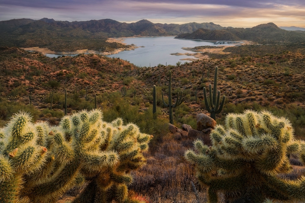
Nestled within the rugged terrain of the Tonto National Forest, Bartlett Lake emerges as a shimmering oasis amid the arid Arizona landscape. The lake’s turquoise waters reflect the surrounding desert mountains, creating a striking contrast between the deep blue surface and the earthy tones of the Sonoran Desert. Located just 48 miles northeast of downtown Phoenix (GPS coordinates: 33.8298° N, 111.6261° W), this hidden gem offers a perfect escape from urban life without requiring a lengthy journey.
Accessibility is one of Bartlett Lake’s greatest assets. Visitors can reach the lake via the fully paved Bartlett Dam Road (Forest Road 19), which connects to Cave Creek Road (Forest Road 24) near the town of Carefree. The drive from Phoenix Sky Harbor International Airport takes approximately 75 minutes, making it an ideal destination for both day trips and extended stays. The newly engineered road system combined with Phoenix’s expanding freeway network ensures smooth access from anywhere in the Valley of the Sun.

The story of Bartlett Lake begins in the late 1930s during the Great Depression. As part of the Salt River Project, Bartlett Dam was constructed between 1936 and 1939 to provide flood control and irrigation water for the Salt River Valley and the Salt River Indian Reservation. The dam and lake were named after Bill Bartlett, a government surveyor who first identified the dam site while surveying the Verde River. When completed in May 1939, the dam was the tallest multiple-arch dam in the world at that time. The man-made reservoir plays a crucial role in Arizona’s water system, serving as a vital storage facility in the Salt River Project’s complex network of dams and reservoirs that supply water to the Phoenix metropolitan area.

The striking contrast between the blue water, desert landscape, and mountain backdrops creates exceptional photography opportunities. Sunrise and sunset are particularly spectacular as the changing light paints the surrounding Mazatzal Mountains and desert terrain in dramatic colors.

The lake features designated swimming areas with sandy beaches, making it ideal for families. Yellow Cliffs and Rattlesnake Cove offer popular swimming spots with gradual-entry shorelines. The water temperature is particularly pleasant from late spring through early fall, providing refreshing relief from the Arizona heat.

Bartlett Lake offers excellent boating opportunities on its 2,815 acres of water surface. The lake accommodates all types of watercraft from kayaks and canoes to speedboats and pontoons. The open water and scenic surroundings make it perfect for cruising, while the lake’s size provides ample space for water skiing, wakeboarding, and jet skiing without feeling crowded.

Bartlett Lake is renowned for its diverse fishing opportunities. Anglers can target largemouth bass, smallmouth bass, crappie, bluegill, and channel catfish. The lake features numerous coves and structures that create ideal fishing habitats. Spring and fall typically offer the best fishing conditions, though year-round fishing is available with seasonal variations in catch rates and species activity.

The area surrounding Bartlett Lake features several hiking trails that showcase the diverse Sonoran Desert landscape. These paths wind through saguaro forests, along desert washes, and up to viewpoints offering panoramic vistas of the lake and surrounding mountains. The Palo Verde Trail and Jojoba Trail are popular options for hikers of various skill levels.

Bartlett Lake’s location in the Tonto National Forest makes it a habitat for diverse desert wildlife. Visitors can spot desert mule deer, javelina, coyotes, and numerous bird species including bald eagles, ospreys, great blue herons, and various waterfowl. Dawn and dusk are typically the best times for wildlife observation.

Bartlett Lake offers both developed campgrounds and shoreline camping opportunities. The Bartlett Lake Campground provides amenities like restrooms, picnic tables, and fire rings, while dispersed camping allows for a more rustic experience along certain sections of the shoreline. The starry nights and peaceful surroundings create a memorable outdoor experience.

Multiple developed recreation sites around Bartlett Lake provide picnic tables, grills, and shade ramadas for day visitors. These areas offer stunning views of the lake and surrounding mountains, making them perfect spots for family gatherings or peaceful lakeside meals.
Bartlett Lake has earned a well-deserved reputation as an angler’s paradise since the dam’s completion in 1939. The lake hosts a diverse array of game fish that attract fishing enthusiasts year-round. Primary species include largemouth bass, smallmouth bass, crappie, bluegill, channel catfish, flathead catfish, and carp. Several state fishing records have been set at Bartlett Lake, including the 1977 smallmouth bass record weighing seven pounds and the carp state record of 37 pounds, 5 ounces, which still stands today.
The lake’s fishing hotspots are distributed throughout its waters, with certain areas known for particular species. “Fish City” near Bartlett Flat is a fish-habitat improvement project that has enhanced the aquatic environment, creating structure that attracts various fish species. The deeper waters near the dam tend to be productive for catfish, especially the large flatheads that lurk in the depths, while the coves and shoreline areas with vegetation or submerged trees offer good habitat for bass and crappie.
Seasonal patterns significantly affect fishing success at Bartlett. Spring (March through May) is generally considered prime fishing season as water temperatures rise and fish become more active, particularly for bass during their spawning period. During summer, early morning and evening fishing yields the best results as fish seek deeper, cooler waters during the heat of the day. Fall brings another period of increased activity as fish feed heavily before winter, while winter fishing slows but can still be productive, especially for crappie.
Fishing regulations at Bartlett Lake follow Arizona Game and Fish Department guidelines, with specific bag and possession limits for each species. All anglers 10 years and older must possess a valid Arizona fishing license, which can be purchased online through the Arizona Game and Fish Department website or at licensed vendors including the Bartlett Lake Marina store. The lake occasionally hosts fishing tournaments, particularly for bass, which are typically organized by local fishing clubs or the marina.
For those seeking professional guidance, fishing guides are available for hire through the marina or independent operators, offering valuable local knowledge and equipment for both novice and experienced anglers. The marina store stocks essential fishing supplies, including live bait, tackle, and ice, ensuring visitors have everything needed for a successful day on the water.
Boating is perhaps the most popular activity at Bartlett Lake, with its expansive surface area providing ample room for various watercraft. The lake permits both motorized and non-motorized vessels, though some restrictions apply. Motors producing noise levels exceeding 82 decibels are prohibited, and all watercraft must follow Arizona boating laws, including having proper safety equipment aboard.
Four primary boat launch facilities serve the lake:
During peak summer weekends, these launch areas can become congested, so early arrival is recommended. Each launch facility offers varying levels of amenities, but all have parking areas, though capacity varies by location. The ramps are generally well-maintained by the Tonto National Forest Service, though water levels can affect usability during drought periods.
Navigation hazards are minimal but include submerged objects during low water levels and shallow areas in some coves. Boaters should be aware that certain areas, including Rattlesnake Cove, are designated as “No-Wake” zones, clearly marked by buoys. Additionally, the northern end of the lake is closed to water-skiing, and any part of the Verde River that is free-flowing is closed to motorized watercraft. Boat traffic is required to move in a counter-clockwise direction around the lake for safety.
Bartlett Lake Marina offers a variety of boat rental options, including pontoon boats, fishing boats, and personal watercraft. The marina also provides wet slips and dry storage for private boats, along with a full-service fuel dock and pump-out station. For those who enjoy boating but prefer not to own, the Bartlett Lake Marina Boat Club offers a membership program that provides access to a fleet of vessels without the hassle of ownership.
Due to the lake’s popularity, authorities enforce limits on the number of boats allowed on the lake during peak periods. Local radio stations often broadcast updates on crowd conditions during summer weekends, helping visitors plan accordingly.
Bartlett Lake’s pristine waters and numerous sandy beaches make it an ideal destination for swimming and water sports enthusiasts, particularly during Arizona’s hot summer months. The western shoreline features gently sloping beaches with sandy coves perfect for swimming, while the eastern side’s mountainous terrain helps break the wind, creating favorable conditions for water sports.
Designated swimming areas include:
These swimming areas do not have lifeguards, so visitors should exercise appropriate caution. Water quality is regularly monitored and is generally excellent, though algae blooms can occasionally occur during hot periods. Swimming is best enjoyed from late spring through early fall when water temperatures are most comfortable, ranging from the high 60s to the mid-80s (°F).
Water sports flourish at Bartlett Lake, with water skiing and wakeboarding particularly popular due to the lake’s size and relatively calm conditions. Jet skiing is another favorite activity, with rentals available through Extreme Arizona operating out of Bartlett Lake Marina. The lake’s expansive surface area allows for high-speed activities while still providing quieter coves for more relaxed water play.
For those preferring non-motorized water activities, stand-up paddleboarding and kayaking offer peaceful ways to explore the shoreline and coves. Equipment rentals for these activities are also available at the marina. The best locations for these activities are the numerous secluded coves along the shoreline, particularly in the morning hours when the water is typically calmest.
Area-specific restrictions include the closure of Rattlesnake Cove to all motorized watercraft and the northern end of the lake being closed to water-skiing. These restrictions help ensure the safety and enjoyment of all visitors by separating potentially conflicting activities.
During peak summer weekends, the popular swimming beaches can become crowded. Visitors seeking more solitude can find quieter coves by walking a short distance along the shoreline from the main access points, where many private, scenic spots can be discovered among the rock formations and saguaro cacti that line the water’s edge.
| Feature | Details |
|---|---|
| Location | Tonto National Forest, Maricopa County, northeast of Phoenix |
| Formation | Created in 1939 by the construction of Bartlett Dam on the Verde River |
| Size | Approximately 2,815 acres when full (surface area) |
| Length | About 12 miles long |
| Elevation | 1,620 feet (494 m) |
| Water Source | Verde River |
| Dam | Bartlett Dam: 287 feet high, 800 feet long concrete multiple-arch structure |
| Purpose | Water supply, flood control, recreation |
| Maximum Depth | Approximately 180 feet near the dam |
| Water Capacity | 178,186 acre-feet |
| Surroundings | Scenic desert mountains, Sonoran Desert vegetation (saguaros, cholla, palo verde) |
| Access | Via Bartlett Dam Road, fully paved access (Forest Road 205) |
| Distance from Phoenix | Approximately 48 miles from downtown Phoenix |
| Recreation | Fishing, boating, water skiing, wakeboarding, jet skiing, paddleboarding, kayaking, swimming |
| Fish Species | Largemouth bass, smallmouth bass, crappie, bluegill, channel catfish, flathead catfish |
| Facilities | Multiple marinas (Bartlett Lake Marina, Jojoba Boating Site), boat ramps, picnic areas |
| Marina Services | Boat rentals, restaurant, convenience store, fuel |
| Camping Options | Yellow Cliffs, Bartlett Flat, SB Cove, Horseshoe Bend developed sites |
| Notable Features | “Arizona’s Best Sunset Lake” due to its east-west orientation |
| Best Seasons | Spring for wildflowers; fall and winter for fishing |
| Wildlife | Bald eagles, herons, deer, javelina, coyotes |
Bartlett Lake is known for its accessibility compared to other lakes in the region, offering a full-service experience with developed facilities while maintaining a scenic desert setting. Its popularity stems from its proximity to Phoenix combined with its stunning Sonoran Desert backdrop of mountains and saguaro-covered hills. The lake’s water levels can vary significantly throughout the year based on precipitation and water management needs, affecting both its appearance and recreational opportunities.
Bartlett Lake stands as the second-largest lake in the Phoenix area, surpassed only by Lake Pleasant. With a boatable surface area of 2,815 acres, it exceeds the combined size of nearby Saguaro and Canyon Lakes. The reservoir extends approximately 12 miles in length when at full capacity, with a shoreline that stretches for 33 miles, offering ample space for various recreational activities.
The lake’s depth varies throughout, with an average depth of approximately 100 feet and reaching a maximum depth of 174 feet near the dam. This significant depth helps maintain relatively stable water levels throughout the year, though seasonal fluctuations do occur based on precipitation patterns and water management needs.
Bartlett Lake is primarily fed by the pristine waters of the Verde River, which indigenous peoples of the region referred to as having “sweet waters” in their legends. The river’s watershed collects runoff from the mountains of central Arizona, ensuring a relatively consistent water supply. The water quality is regularly monitored by the Arizona Department of Environmental Quality, maintaining safe conditions for recreational use, though clarity varies seasonally, with the best visibility typically occurring in spring and early summer. Water temperatures range from the 50s (°F) in winter to the 80s during the hot summer months, providing a refreshing escape from the desert heat.
The lake features a fascinating geographical dichotomy. The western shoreline presents gently sloping beaches with sandy coves perfect for swimming and shoreline activities, while the eastern side is characterized by more dramatic, mountainous terrain that helps break the wind and creates sheltered areas for boating. This unique combination makes Bartlett Lake particularly versatile for different recreational pursuits.
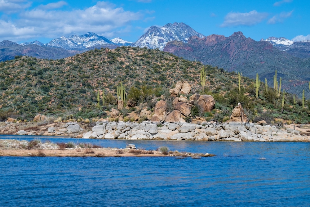
The surrounding landscape showcases the diverse beauty of the Sonoran Desert ecosystem. The area is rich with indigenous desert flora, including the iconic saguaro cactus, mesquite trees, palo verde, and seasonal wildflowers. After wet winters, the surrounding hills transform with vibrant displays of spring wildflowers, creating a spectacular backdrop for visitors. The lake’s elevation of approximately 1,600 feet above sea level places it in a transition zone between desert and higher elevation ecosystems, contributing to the area’s rich biodiversity.
The impressive Bartlett Dam stands as a testament to early 20th-century engineering ingenuity and the determination to harness water resources in the arid Southwest. Construction began in August 1936 and was completed in May 1939, remarkably finishing on time in exactly 1,000 days as specified in the contract, and coming in under budget by $270,000—a significant sum during the Great Depression era.
Bartlett Dam is classified as a concrete multiple-arch buttress dam, a design chosen for its strength and efficiency in using less concrete than other dam types. Originally, the dam stood 287 feet tall, but safety modifications in the mid-1990s increased its height to 308.5 feet. The structure spans 823 feet in length and consists of 10 arches, 9 buttresses, and is flanked by 2 gravity wing dams. When first completed, it contained 182,000 cubic yards of concrete, which increased to 223,773 cubic yards after modifications.
The dam’s construction was a collaborative effort funded 80% by the Salt River Project (SRP) and 20% by the Bureau of Indian Affairs, with the actual construction carried out by the U.S. Bureau of Reclamation. It represents the first dam of its type constructed by the Bureau and was, at its completion, the tallest multiple-arch dam in the world. The primary purposes for building the dam were to provide flood control for the unpredictable Verde River and to create a reservoir of irrigation water for both the Salt River Valley residents and the Salt River Indian Reservation.
The dam is currently managed by the Salt River Project (SRP), a utility company that provides water and power to central Arizona. Unlike some other dams in the Salt River Project system, Bartlett Dam does not include hydroelectric power generation facilities, focusing solely on water storage and flood control functions.
Between 1994 and 1996, the Bureau of Reclamation undertook significant modifications to address safety concerns. These improvements included raising the dam by 21.5 feet to prevent overtopping during extreme flood events, modifying the service spillway, and constructing a new unlined auxiliary spillway about 1,500 feet south of the dam’s left abutment. This auxiliary spillway features a concrete control structure and a three-segment fuse plug embankment designed to erode in specific stages during flooding, providing additional protection against catastrophic dam failure.
The dam’s outlet works have a discharge capacity of 2,400 cubic feet per second, allowing controlled releases into the lower Verde River. The reservoir created by the dam has a capacity of approximately 178,186 acre-feet of water at normal surface elevation of 1,798 feet.
While the dam itself is not open for public tours, visitors can view it from designated areas around the lake. The structure was listed on the National Register of Historic Places in 2017, recognizing its historical significance and engineering achievement. For those interested in the history of water management in the Southwest, Bartlett Dam represents an important chapter in Arizona’s development and the efforts to transform the desert into the thriving region it is today.
Camping at Bartlett Lake offers visitors the chance to experience the Sonoran Desert’s beauty up close, with several options catering to different preferences and equipment. The primary camping areas include:
Bartlett Flat Camping Area:
Yellow Cliffs Camping Area:
SB Cove:
The camping season extends year-round, though summer brings intense heat (often exceeding 100°F) that can be challenging for those unaccustomed to desert conditions. Spring (March-May) and fall (October-November) offer the most pleasant weather, with mild days and cool nights. Winter camping (December-February) provides solitude and comfortable daytime temperatures, though nights can drop below freezing.
Most camping areas operate under standard Tonto National Forest regulations, including:
For visitors preferring more comfortable accommodations, several options exist within a 30-minute drive:
Nearby Hotels/Motels:
Alternative Camping:
Unique Options:
Accessibility for visitors with disabilities varies by location. Yellow Cliffs has some accessible facilities, including designated parking and accessible picnic areas. The Bartlett Lake Marina area offers the most accessible amenities, including paved pathways and accessible restrooms.
Camping at Bartlett Lake provides a true desert experience, with the unique opportunity to sleep under star-filled skies next to water—a rare combination in Arizona. The contrast between the lake and surrounding desert creates a special environment that draws visitors back season after season.
The ecosystem surrounding Bartlett Lake represents a fascinating intersection of aquatic and desert environments, creating a biodiversity hotspot within the Sonoran Desert. This unique setting supports a rich variety of plant and animal species adapted to the challenging conditions of this transitional zone.
The flora around Bartlett Lake showcases classic Sonoran Desert vegetation with some riparian influences. The iconic saguaro cactus (Carnegiea gigantea) stands sentinel on hillsides, sometimes growing right to the water’s edge—creating postcard-worthy vistas unique to Arizona. Other common plant species include:
After wet winters, the landscape transforms with spectacular wildflower displays, featuring Mexican gold poppies, lupines, brittlebush, and desert marigolds, typically peaking in March and April.
Birdwatching is particularly rewarding at Bartlett Lake, with over 200 species recorded in the area. Year-round residents include:
Migratory species add diversity seasonally, with winter bringing various waterfowl and spring/fall migration bringing additional songbirds through the area.
Mammals commonly observed include:
Reptiles thrive in this environment, with common species including:
The aquatic ecosystem supports various native and introduced fish species, creating a productive fishery. Amphibians include Sonoran Desert toads and various frog species near the water’s edge.
The best wildlife viewing locations include:
Conservation efforts at Bartlett Lake focus on balancing recreational use with habitat protection. The Tonto National Forest manages wildlife habitat, with specific programs addressing:
Several nature trails provide opportunities to explore the ecosystem, though none are formally developed as interpretive trails. The lake area serves as an important outdoor classroom for understanding desert adaptations and riparian influences, with the dramatic meeting of water and desert creating a living laboratory for ecological study.
Bartlett Lake offers year-round recreational opportunities, though each season brings distinct advantages and challenges for visitors. Understanding these seasonal patterns helps ensure an optimal experience at this desert oasis.
Spring (March-May): Perhaps the most idyllic time to visit Bartlett Lake. Daytime temperatures typically range from the mid-70s to mid-80s°F, creating perfect conditions for almost all activities. Water temperatures gradually warm from the 60s to the 70s°F, making swimming increasingly pleasant as the season progresses. This period often brings spectacular wildflower displays, particularly after wet winters, with hillsides covered in Mexican gold poppies, lupines, and brittlebush. For anglers, spring represents prime fishing season as bass enter their spawning period. March and April weekends can be crowded, especially during spring break periods and holiday weekends. Water levels are typically at their highest in early spring following winter precipitation.
Summer (June-September): The busy season despite intense heat. Daytime temperatures frequently exceed 100°F, occasionally reaching 110°F or higher. Early mornings (before 10 AM) and evenings offer more comfortable conditions. Water temperatures peak in the low to mid-80s°F, providing refreshing relief from the heat. Afternoon thunderstorms are possible during the monsoon season (typically July-September), bringing sudden strong winds and brief heavy rainfall. These storms can develop quickly, so boaters should remain weather-aware. Fishing becomes more challenging, with most activity occurring early morning or evening. The lake can reach capacity limits on summer weekends, particularly holidays, sometimes resulting in temporary closures to additional visitors. Arrive early (before 9 AM) to ensure entry during peak periods.
Fall (October-November): A delightful season as temperatures moderate. Daytime readings typically range from the 70s to 80s°F early in fall, dropping to the 60s and 70s°F by November. Water temperatures gradually cool but remain comfortable for swimming through October. Fall brings fewer visitors, especially on weekdays, offering a more peaceful experience. This season provides excellent conditions for hiking the surrounding trails and exploring the shoreline. Fishing improves as water temperatures drop, with bass and crappie becoming more active. Water levels can be lower after summer demand, potentially exposing some shoreline and creating different fishing conditions.
Winter (December-February): The quietest season, offering solitude and beauty. Daytime temperatures typically range from the 50s to 60s°F, with occasional warmer days. Nights can drop below freezing, particularly in January. Water temperatures cool to the 50s°F, generally too cold for comfortable swimming but still suitable for boating and fishing. Clear, crisp days create spectacular visibility and stunning photography opportunities. Winter rainfall can occasionally cause temporary road issues, though the main access road remains well-maintained. Camping requires preparation for cold overnight temperatures. Crappie fishing can be particularly productive during winter months. Lower visitor numbers mean easy access to prime spots and a more wilderness-like experience.
Seasonal Events and Activities:
Water Level Fluctuations: As a reservoir primarily designed for water storage and flood control, Bartlett Lake experiences significant water level changes throughout the year. Levels typically peak in early spring following winter precipitation, gradually declining through summer and fall as water is released for downstream use. During drought periods, these fluctuations can be more dramatic. Lower water levels expose more shoreline for camping but can affect boat launch access at some ramps. The Salt River Project provides water level information (602-236-5929) that can be helpful for planning visits during periods of significant fluctuation.
Fees and Permits:
Operating Hours and Seasonal Closures:
Ranger Stations and Services:
Emergency Services:
Cell Phone Reception:
Accessibility Features:
Drinking Water Availability:
Waste Disposal and Recycling:
Fire Regulations:
Pet Regulations:
The area surrounding Bartlett Lake offers numerous opportunities to extend your visit with diverse attractions, services, and cultural experiences. Within a short drive, visitors can explore charming towns, historical sites, and natural wonders that complement the lake experience.
Nearby Towns and Facilities:
Cave Creek/Carefree (18-22 miles from the lake): These adjacent communities offer the closest services to Bartlett Lake, each with distinct character.
North Scottsdale (25-30 miles from the lake): The upscale northern section of Scottsdale provides additional services and shopping.
Other Attractions Within a 1-Hour Drive:
Seven Springs Recreation Area (15 miles):
Cave Creek Regional Park (20 miles):
Spur Cross Ranch Conservation Area (20 miles):
Tonto National Monument (55 miles):
McDowell Mountain Regional Park (30 miles):
Cultural and Historical Significance:
The Bartlett Lake area has rich cultural history tied to indigenous peoples, western settlement, and water management in the arid Southwest.
Indigenous History:
Western Settlement:
Development of Phoenix:
Local Recommendations and Hidden Gems:
For visitors seeking to understand the complete story of the region, these nearby attractions provide valuable context to the lake experience, highlighting how water, geology, and human history have shaped this corner of Arizona.
Essential Packing List:
For All Visitors:
For Boaters: