The sun beats down mercilessly on crumbling adobe walls and weathered stone foundations scattered across the stark desert landscape. Nearby, a small cemetery perched on a built-up mound stands as a quiet sentinel, its wooden crosses and modest headstones leaning at odd angles against the endless blue sky. This is Agua Caliente, a ghost town that whispers stories of hope, healing, and hardship in southern Arizona’s unforgiving terrain.
Located in Maricopa County near the Yuma County border, Agua Caliente—Spanish for “hot water”—once drew people from across the Southwest to its natural hot springs that promised relief and rejuvenation. Today, these healing waters have long since dried up, leaving only memories etched in stone ruins and marked graves. The silent buildings and weathered cemetery markers tell a compelling story of human ingenuity and perseverance in a harsh environment, while also serving as a stark reminder of the impermanence of human endeavors against the timeless desert backdrop.

To visit Agua Caliente is to step back into a world where pioneers, cowboys, indigenous peoples, and settlers all converged around the rare gift of thermal waters in the desert. It is a place where life and death, prosperity and hardship, boom and bust played out over generations, leaving behind both physical remains and spiritual echoes for those willing to listen. This forgotten corner of Arizona reveals how closely intertwined the community’s story is with its cemetery—both representing journeys that ended in this remote outpost, where dreams of prosperity were ultimately reclaimed by the desert.


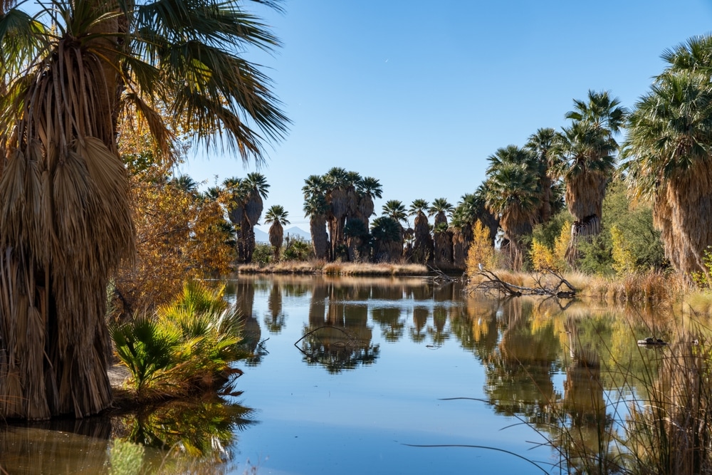
The centerpiece of Agua Caliente is its natural thermal springs, which have drawn visitors for centuries. These springs naturally maintain temperatures between 95-105°F year-round, rich in minerals believed to have therapeutic properties. The main spring produces approximately 150,000 gallons of crystal-clear water daily. These waters emerge from deep underground aquifers heated by geothermal activity, creating a natural spa experience in the desert. Native peoples considered these springs sacred healing grounds long before European settlement.

A lush desert oasis surrounds the springs, featuring native California fan palms (Washingtonia filifera) that create a striking contrast against the stark desert landscape. Some of these magnificent palms exceed 60 feet in height and are estimated to be over a century old. The dense palm canopy creates microhabitats supporting unique plant communities and wildlife. This rare riparian environment demonstrates how natural water sources transform arid landscapes into havens of biodiversity

Archaeological evidence indicates human use of these springs dating back thousands of years. The area holds significant cultural importance for the Cahuilla people, who incorporated the springs into their traditional lifeways and healing practices. Stone implements, pottery fragments, and food processing areas discovered near the springs document extensive indigenous occupation. Interpretive displays highlight this rich cultural heritage and the sophisticated adaptation strategies developed by desert peoples.

Shaded picnic facilities nestled among palm trees provide ideal settings for outdoor meals. These areas feature tables, grills, and nearby restroom facilities, creating comfortable spaces for family gatherings. The juxtaposition of towering palms, flowing water, and desert landscape creates a uniquely tranquil dining environment. These designated areas allow visitors to enjoy extended time on the property while minimizing environmental impact on sensitive habitats.
The relatively dark skies and minimal light pollution create excellent conditions for astronomical observation. The clear desert air and elevation enhance visibility of celestial objects. During winter months, organized stargazing events feature telescopes and knowledgeable guides helping visitors identify constellations, planets, and deep-space objects. The contrast between the warm springs experience and cool desert nights creates memorable opportunities to connect with both terrestrial and cosmic environments.

The oasis environment attracts an exceptional diversity of bird species, making Agua Caliente a premier destination for birders. Over 150 species have been documented, including resident desert specialists and seasonal migrants. The verdant palm groves provide critical habitat for species like the hooded oriole, which nests exclusively in palm trees. During migration seasons, the contrast between surrounding desert and water-rich oasis creates a magnet for birds traveling along the Pacific Flyway.
Agua Caliente was a significant hot springs site and ghost town in Arizona with a fascinating history. Here’s what makes it notable:
| Feature | Details |
|---|---|
| Location | Northeastern Maricopa County, near the Gila River |
| Active Period | 1870s-1940s |
| Key Attraction | Natural hot springs with reported therapeutic properties |
| Historical Significance | Once a prominent health resort and stagecoach stop |
| Peak Development | Featured a hotel, bathhouse, post office, and store |
| Famous Visitors | Reportedly visited by U.S. Presidents including Theodore Roosevelt |
| Transportation | Served by the Southern Pacific Railroad during its heyday |
| Decline | Gradual abandonment after the springs began to dry up |
| Current Status | Ghost town with few remaining structures |
| Ownership | Now largely on private property with limited public access |
| Notable Structures | Stone bathhouse remains and foundations of other buildings |
| Cultural Connection | Previously used by Native Americans for the healing properties of the springs |
| Geographic Features | Located near the Sierra Estrella Mountains |
| Historical Recognition | Considered an important part of Arizona’s frontier history |
| Alternative Names | Sometimes called “Aguacaliente” or “Agua Caliente Ranch” |
The name “Agua Caliente” means “hot water” in Spanish, directly referencing the natural hot springs that were the town’s primary attraction and reason for existence. Though little remains today, it represents an important chapter in Arizona’s development as both a health destination and transportation hub.
The story of Agua Caliente begins long before European settlers arrived in what is now Arizona. The natural hot springs that would eventually give the settlement its name were first utilized by indigenous peoples, particularly the Tonto Apache tribe, who recognized the therapeutic properties of the thermal waters bubbling up from deep within the earth. These native inhabitants considered the springs sacred, using them for healing rituals and medicinal purposes.
European documentation of the area began in 1744 when Father Jacob Sedelmayer, a Jesuit missionary, named the location “Santa Maria del Agua Caliente.” By 1775, Father Francisco Garces had shortened the name to simply “Agua Caliente,” the designation that would remain throughout its history.
Following the Mexican-American War and the 1853 Gadsden Purchase, the area came under American control. By 1858, travelers along the Gila River route could find Flap-Jack Ranch located six miles from the Agua Caliente hot springs, which served as a stagecoach station for the Butterfield Overland Mail line. The area took on strategic importance during the American Civil War when nearby Stanwix Ranch (also called Stanwix Station) became the site of the westernmost skirmish of the conflict in 1862. The California Column, Union troops moving eastward during the war, stopped at the hot springs to enjoy the soothing waters.
The most significant early development of Agua Caliente came under the ownership of King Samuel Woolsey, a controversial Arizona pioneer who would later become a territorial legislator. In the early 1860s, Woolsey partnered into the Agua Caliente Ranch near an abandoned Butterfield Stage Station named Stanwix. Under Woolsey’s direction, the ranch began to develop around the natural hot springs.
By 1864, when travel writer John Ross Browne visited, the ranch was being managed by Woolsey’s partner, a Mr. Martin, who was attempting to establish a farm using irrigation. Browne wrote enthusiastically about his experience at the springs: “We had a glorious bath in the springs next morning, which completely set us up after the dust and grit of the journey.”
By 1873, Woolsey had established Agua Caliente Ranch as a well-known destination, and people were traveling considerable distances to experience the reputed healing properties of the thermal waters. Woolsey’s influence extended beyond the ranch itself—he secured a contract to build a road between Phoenix and Yuma that ran directly through Stanwix and Agua Caliente, ensuring the settlement’s connection to larger population centers.
The biggest development in Agua Caliente’s history came in 1897 when a 22-room resort hotel was built on the site of Woolsey’s former ranch. The “Agua Caliente Hotel” featured a swimming pool fed by the hot springs, allowing visitors to enjoy the therapeutic waters in comfort. The resort quickly gained a reputation for its healing properties, attracting visitors from across Arizona and beyond.
Among its notable guests was George W.P. Hunt, who would later become Arizona’s first elected governor. At the turn of the century, Agua Caliente had evolved from a simple ranch into a modest but prosperous small town with a hotel, residences, a store, a saloon, and a community cemetery. According to census records, Agua Caliente reported a population of 113 in 1900.
The Bisbee Daily Review advertised the resort’s healing powers in December 1904: “Agua Caliente is the place for all people who are sick as well as those who are well, to visit and obtain speedy relief. RHEUMATISM and BLOOD DISEASES cured.” The desert oasis had become a destination for health tourism, promising respite from various ailments through its mineral-rich waters.
The community continued to appear in census records as the Agua Caliente Precinct of Maricopa County in 1910, as Precinct 54 in 1920, and again as Agua Caliente Precinct in 1930. By 1940, the population had decreased to approximately 60 residents, signaling the beginning of the town’s decline.
Today, Agua Caliente exists primarily as scattered ruins that require some determination to locate. Visitors who make the journey will find the remains of the once-bustling resort approximately 28 miles west of Gila Bend on Interstate 8. After exiting at Sentinel and traveling north on Agua Caliente Road for about 10 miles, then turning west on Old Agua Caliente Road, explorers will encounter the ghost town about a mile further.
The most substantial remnant is the shell of the 22-room Agua Caliente Hotel, though it sits on private property surrounded by “No Trespassing” signs. The building, while still standing, shows the ravages of time and neglect. The swimming pool that once held the healing thermal waters now lies empty, a concrete hollow in the desert floor.
Around the main hotel building are various stone ruins of cabins and outbuildings, many reduced to mere foundations or partial walls. One small shack reportedly remains standing, along with the remains of what was once a store and other structures. The ruins include several stone buildings, some with walls still intact. The largest building measures approximately 25 by 50 feet and is surrounded by a curtain wall that may have served as either a courtyard enclosure or protection against potential threats from bandits or hostile encounters.
The property currently belongs to a private owner who maintains a caretaker on site in a trailer near the hotel. The entire resort area is fenced and clearly marked as private property, making legal access to the main buildings impossible without permission. However, the community cemetery across the road remains accessible to visitors interested in this aspect of Agua Caliente’s history.
Agua Caliente’s decline can be attributed to several factors, with the loss of its main attraction—the hot springs themselves—being the most significant. Over time, the thermal waters that had drawn visitors for generations gradually dried up, primarily due to over-irrigation by nearby farms and ranches that drained the aquifer. Some reports suggest that development efforts may have contributed to the springs’ demise, with one account claiming that developers used dynamite to expand the resort area, inadvertently destroying the natural springs in the process.
Transportation changes also played a crucial role in the town’s abandonment. As newer, more direct routes were established across Arizona, Agua Caliente found itself bypassed by modern transportation networks. The Southern Pacific Railroad chose a route that didn’t service the community, and later, both Arizona State Highway 85 and Interstate 8 bypassed the once-popular resort destination.
The town experienced a brief revival during World War II when a swimming pool was constructed specifically for the use of military officers from nearby Camp Horn. The conflict brought temporary activity back to Agua Caliente, but once the war ended, the decline continued unabated. By the 1950s, most residents had departed, leaving the buildings to slowly succumb to the harsh desert environment.
Today, the property encompasses approximately 2,700 acres, some of which is used for farming, while the majority remains in its natural state. A caretaker continues to live on the property, maintaining a watchful eye over the ruins of what was once a thriving desert oasis.
The Agua Caliente Pioneer Cemetery stands on a built-up mound on the south side of Old Agua Caliente Highway, approximately one mile east of the former hot springs resort. This elevated position may have been chosen both for practical reasons—keeping the burial ground above potential flood levels—and symbolic ones, creating a dignified final resting place overlooking the desert valley.
The cemetery is relatively small but contains approximately 123 interments according to historical records. Of these, about 45 graves are marked with headstones, wooden crosses, or other monuments, while approximately 78 remain unmarked. Despite its remote location and exposure to harsh elements, the cemetery has been described by visitors as “well-taken care of,” suggesting that descendants or interested parties continue to maintain this historical burial ground.
The layout of the cemetery follows a general pattern, with more recent burials concentrated at the southern end and older graves situated toward the northern section closer to the ghost town ruins. This arrangement creates a chronological narrative of the community’s development and eventual decline, readable in the progression of graves across the landscape.
The Agua Caliente Pioneer Cemetery contains burials spanning more than a century, with the oldest documented grave dating back to 1880 (that of Jesus Cruz) and the most recent burials occurring well into the 21st century—as recent as 2009 with the interment of Kathleen Martin. This continuing use of the cemetery, long after the town itself was abandoned, speaks to the deep connections maintained by families with historical ties to the area.
Among the oldest burials are those of a husband born in 1835 and his wife born in 1836, representing some of the earliest pioneers to settle in the area. Their graves, like many of the older plots, may be marked only by simple wooden crosses or stone markers, many of which have deteriorated over time.
The cemetery contains several U.S. military headstones, honoring veterans who once called this remote desert community home. One particularly notable military grave belongs to Joseph Ray “Pee Wee” Arivasca (December 2, 1914 – April 9, 2007), a U.S. Navy veteran who served during the Vietnam War. His bronze headstone features cattle brands and the inscription “Riding With The Old Ones,” reflecting his background as a cattle rancher whose ancestors had raised cattle along the Gila River since the 1800s.
Another distinctive marker belongs to Steven Duane Eddy (February 27, 1952 – May 22, 1975), who died at the young age of 22. His headstone features carvings of a saguaro cactus, a mountain, and an elk, along with the inscription “Came to Hyder in ’65,” referencing the nearby settlement where he spent his childhood.
One small plot area contains two small graves marked with wooden headstones, believed to be the final resting place of unknown twin girls—a poignant reminder of the high infant mortality rates in frontier communities.
The cemetery serves as a testament to the family connections that formed the backbone of the Agua Caliente community. The graves reflect the presence of several prominent family groups that maintained multi-generational ties to the area. Among these are:
These family groupings provide insight into the community’s demographic makeup, which included a significant Hispanic population. Many of the surnames indicate Mexican or Spanish heritage, reflecting the borderland character of southern Arizona and the continuous movement of people and cultures across this desert region.
The presence of these family groups, with burials spanning multiple generations, indicates a community with deep roots and strong kinship ties. Despite the eventual abandonment of the town itself, these families maintained their connection to Agua Caliente through their continued use of the cemetery, ensuring that their ancestors would remain together even as the living community dispersed.
The headstones and burial records of the Agua Caliente cemetery offer insights into the diversity of the community that once thrived around the hot springs. The predominance of Hispanic surnames—Conde, Amabisca, Perez, Cruz, and others—indicates a strong Mexican-American presence in the settlement. This reflects the broader pattern of the Arizona-Sonora borderlands, where Mexican ranching families often established themselves before the arrival of Anglo-American settlers.
The 1930 census reported that Agua Caliente had a “White majority,” though this classification would have included Hispanic residents under the census categories of the time. The continued use of Spanish language on grave markers and the preservation of Hispanic naming traditions on headstones demonstrate the cultural continuity maintained by these families over generations.
Military headstones in the cemetery represent another demographic segment of the community—those who served in the armed forces. These markers span different conflicts, indicating that the small desert community contributed to American military efforts over multiple generations.
The presence of small children’s graves, including those of infants, tells a story of the hardships faced by frontier families. High childhood mortality rates were common in remote settlements with limited access to medical care, and the cemetery bears witness to these losses with its small markers and brief life spans recorded in stone.
The cemetery displays an evolution of burial practices over its active period from 1880 to the present day. The oldest graves typically feature simple markers—wooden crosses, unadorned stones, or basic headstones with minimal information. As time progressed, more elaborate monuments appeared, reflecting both changing funerary customs and the increased prosperity of some families.
Earlier graves often followed traditional Hispanic Catholic burial customs, with religious symbolism prominently featured on markers. Crosses, religious inscriptions, and references to saints appear frequently on these older stones. The orientation of graves typically followed the Christian tradition of placing the deceased facing east, toward the rising sun symbolizing resurrection.
More recent burials show greater personalization, with markers that reflect the individual’s life, interests, or background. The headstone of Steven Eddy with its carved natural imagery and that of Joseph Arivasca with its cattle brands exemplify this trend toward more personalized memorialization.
The materials used for markers also evolved over time. While early graves might be marked with wooden crosses or locally available stone, later monuments utilized commercially produced headstones made of marble, granite, or bronze. Military graves received standardized government-issued markers according to the conventions of the period in which the veteran died.
Despite these changes in material culture, the cemetery maintains a sense of continuity through its family groupings, with newer burials often placed near those of ancestors, reinforcing kinship connections even in death.
The true heart of Agua Caliente’s history lies in the individual stories of those who lived, worked, and died there. While many of these personal narratives have been lost to time, fragments remain in historical records, newspaper accounts, and the silent testimony of gravestones.
The story of King Woolsey, though he isn’t buried in the cemetery, looms large in Agua Caliente’s history. A controversial figure who ran away from home at 15 and reportedly participated in Central American coups before reaching Arizona, Woolsey established the ranch that would become the foundation for the later resort. His partner Martin’s efforts to establish farming through irrigation represented the optimistic pioneer spirit that drove settlement in this harsh environment.
Mary Woolsey, King’s wife, demonstrated remarkable resilience by managing the Stanwix Stage Station while her husband pursued political ambitions. Running a stage station was dangerous work—station managers at nearby stops had been killed by attackers, yet Mary maintained operations throughout these perilous times. Though documents don’t confirm she’s buried in the cemetery, her story exemplifies the often-overlooked contributions of women to frontier settlements.
Joseph Ray “Pee Wee” Arivasca, whose distinctive grave marker draws visitors’ attention, represents a connection between old and new Arizona. Raised in Yuma and at his family’s cattle ranch near Agua Caliente, he continued the ranching tradition established by his ancestors in the 1800s. His life spanned the transformation of Arizona from frontier territory to modern state, and his military service during Vietnam added another dimension to his frontier heritage.
The cemetery also holds stories of tragedy. Newspaper accounts mention robberies, a saloon keeper shot by a jealous husband, and men who perished in the desert within two miles of help, reportedly “buried on the spot” rather than in the cemetery. These incidents speak to the dangers inherent in desert life and the rough-and-tumble nature of frontier communities.
Holiday celebrations at Agua Caliente could be raucous affairs. A newspaper account of Christmas festivities described events “ushered in with sticks of dynamite, shotguns, etc. and ushered out with the finest conglomeration of swelled heads you ever ran up against.” The correspondent noted that “Agua Caliente booze is something fierce—two drinks will make a jack rabbit spit in a bull dog’s face,” painting a vivid picture of frontier revelry.
These glimpses into individual lives remind us that Agua Caliente was not merely a collection of buildings or an entry in census records, but a community of people with hopes, hardships, celebrations, and sorrows—human experiences now preserved primarily through the markers in the pioneer cemetery.
Agua Caliente’s decline resulted from a perfect storm of environmental, economic, and transportation factors that gradually rendered the once-thriving resort community unsustainable. The most critical blow came with the loss of the hot springs themselves—the very feature that had given the settlement its name and purpose.
By the late 1940s, the thermal springs had dried up completely. This environmental disaster stemmed from several causes. The primary factor was over-irrigation by farms and ranches in the surrounding area, which gradually depleted the aquifer feeding the natural springs. Some accounts also suggest that development efforts may have contributed to the problem, with one source claiming that developers used dynamite to expand the resort area, inadvertently destroying the springs’ natural flow patterns.
Whatever the precise cause, the loss of the hot springs eliminated Agua Caliente’s main attraction. Without the therapeutic waters that had drawn visitors for generations, the resort lost its primary reason for existence.
Simultaneously, changes in transportation infrastructure increasingly isolated the community. The Southern Pacific Railroad bypassed Agua Caliente, directing traffic and commerce to other settlements. Later highway construction, including Arizona State Highway 85 and Interstate 8, further marginalized the location, making it increasingly difficult to attract visitors or maintain commercial connections to larger markets.
These factors combined to create a gradual but inexorable decline. As economic opportunities diminished, residents began to leave, seeking livelihoods elsewhere. Businesses closed, buildings were abandoned, and the community slowly withered.
While Agua Caliente’s decline occurred as a gradual process rather than a sudden abandonment, certain milestones mark its transition from thriving resort to ghost town:
The decline was not a clean break but rather a slow fading, with the community gradually thinning until only empty buildings remained. Even after Agua Caliente was essentially abandoned as a living community, the cemetery continued to receive occasional new burials, maintaining a thread of continuity with the past.
By the mid-20th century, Agua Caliente had dwindled to a handful of residents. The approximately 2,700-acre property eventually came under the ownership of Sam Hughes, who maintained a caretaker on the site to protect the remaining structures from vandalism and unauthorized access.
Today, this caretaker, living in a trailer near the former hotel, represents the last human presence in what was once a bustling small town. The property remains private, with “No Trespassing” signs and fencing surrounding the most significant ruins.
Despite the abandonment of the town itself, connections to Agua Caliente persist through the families who maintain ties to the cemetery. Descendants of the Conde, Amabisca, Perez, and other families continue to visit the burial ground, occasionally adding new interments to the historical cemetery. This ongoing relationship with the cemetery ensures that, while Agua Caliente may be a ghost town in physical terms, its human legacy continues through these family connections.
Agua Caliente occupies a distinctive place in Arizona’s pioneer history as a settlement defined not by mining or agriculture—the economic drivers of many ghost towns—but by its natural hot springs. While numerous ghost towns across Arizona tell stories of boom-and-bust mining operations or failed agricultural ventures, Agua Caliente represents one of the state’s earliest examples of health tourism and recreational development.
The settlement’s history spans multiple significant periods in Arizona’s development—from indigenous use of the springs through Spanish exploration, the American territorial period, statehood, and modern times. This continuity makes Agua Caliente a microcosm of Arizona’s broader historical narrative.
The site’s connection to the Civil War—with nearby Stanwix Station being the location of the conflict’s westernmost skirmish—adds another layer of historical significance. The California Column’s stop at the hot springs places Agua Caliente within the context of this pivotal national event, even if only as a footnote.
King Woolsey’s association with the property links Agua Caliente to Arizona’s territorial politics, as Woolsey served multiple terms in the territorial legislature and was a significant figure in early Arizona governance. His controversial reputation—celebrated by some as a pioneer but criticized by others for his actions against indigenous peoples—makes Agua Caliente part of the complex narrative of frontier settlement and conflict.
While Agua Caliente has not been the subject of extensive formal archaeological investigation, historical documentation of the site exists through various sources. The American Pioneer & Cemetery Research Project (APCRP) has conducted research on the cemetery, documenting burials and creating records of this aspect of Agua Caliente’s history.
Historical photographs preserved in collections such as the Pomona Public Library provide visual documentation of the resort during its operational period. These images capture the buildings, landscape, and occasionally the people of Agua Caliente, offering valuable insights into the community’s physical appearance and daily life.
Newspaper archives, particularly from publications like the Bisbee Daily Review, contain advertisements and accounts that illuminate how the resort presented itself to potential visitors and how it was perceived by contemporaries. These textual sources complement the physical evidence that remains at the site.
The continued presence of substantial ruins, despite decades of exposure to harsh desert conditions, testifies to the quality of construction employed in the original buildings. The stone structures, in particular, have weathered time remarkably well, providing tangible connections to the settlement’s past.
While Agua Caliente itself no longer exists as a living community, its legacy remains important to several groups. For descendants of families buried in the pioneer cemetery, the site represents a direct ancestral connection. The continued use of the cemetery into recent decades demonstrates the enduring significance of this place to these families.
For historians and those interested in Arizona’s pioneer heritage, Agua Caliente provides a well-preserved example of a non-mining ghost town with structures still substantial enough to convey a sense of the original settlement. The relatively intact hotel building, though inaccessible due to private ownership, stands as one of the better-preserved ghost town structures in southern Arizona.